New Orleans Katrina Effects In Google Maps
2005-09-03 10:32 ☼ post
Google Rumors just pointed out that Google has added a Katrina button in Google Maps that show the damage and flooding throughout a good portion of New Orleans.
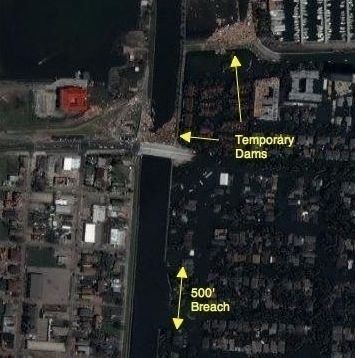 Image created using Google Maps and Flysketch.
After exploring the map a little bit it appears that a good portion of New Orleans to the northwest of downtown and west of Orpheum Ave (which runs along the canal that was breached) is actually dry and largely intact which is promising. The canal flood wall breach is roughly 500 feet long based on the image scale, so it’s no wonder that the Corps of Engineers couldn’t throw a quick patch on it. The image above shows that they were able to block off the canal successfully a little bit further north by a bridge.
Apparently cloud cover was too great to get decent images south of that area though, so it’s impossible to tell what kind of shape the area around Tulane University is in. The majority of the city east of the breach appears to be completely flooded.